Sedona, Arizona, is a hiker’s paradise, offering a vast range of trails that showcase the stunning red rock landscape, majestic views, and even mystical vortexes. Whether you’re looking for a challenging adventure or a peaceful nature walk, Sedona has it all. Here’s a guide to some of the best hiking trails in Sedona, along with helpful links to plan your next hike.
- Cathedral Rock Trail
One of Sedona’s most iconic hikes, Cathedral Rock Trail is a steep but short trail that rewards hikers with breathtaking views. The 1.2-mile round trip is considered moderate to difficult due to the steep ascent, but it’s perfect for those looking to experience Sedona’s spiritual vortexes.
– Trail Difficulty: Moderate to Difficult
– Length: 1.2 miles round trip
– Link: [Cathedral Rock Trail]
(https://www.fs.usda.gov/recarea/coconino/recarea/?recid=55292)
- Devil’s Bridge Trail
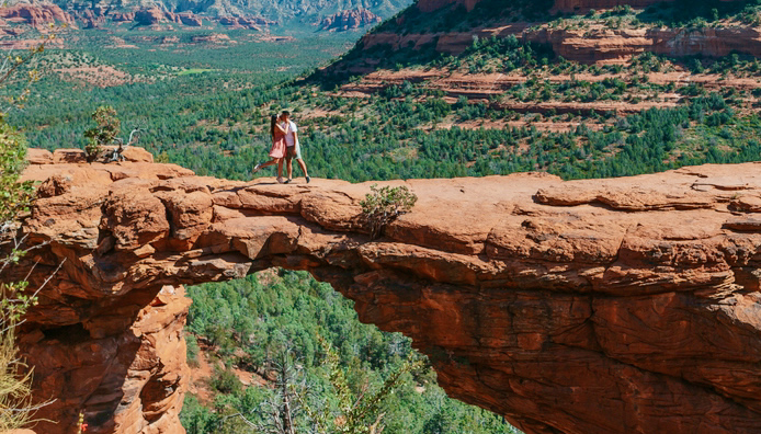
The Devil’s Bridge Trail is famous for its natural rock bridge and is one of the most popular hikes in Sedona. The trail is a moderate 4.2-mile round trip, offering stunning panoramic views of the surrounding red rock formations and a thrilling walk across the bridge itself.
– Trail Difficulty: Moderate
– Length: 4.2 miles round trip
– Link: [Devil’s Bridge Trail]
(https://www.fs.usda.gov/recarea/coconino/recarea/?recid=55132
- Bell Rock Pathway
For a more accessible hike, the Bell Rock Pathway is ideal for all skill levels. This 3.6-mile trail is relatively flat and provides close-up views of the famous Bell Rock and Courthouse Butte. It’s also a popular location for visitors seeking Sedona’s energy vortexes.
– Trail Difficulty: Easy to Moderate
– Length: 3.6 miles round trip
– Link: [Bell Rock Pathway](
https://www.fs.usda.gov/recarea/coconino/recarea/?recid=55318)
- West Fork Trail
West Fork Trail is one of the most beautiful and shaded hikes in Sedona, following Oak Creek through a lush canyon. This 6.5-mile out-and-back trail is perfect for a peaceful nature walk, featuring a mix of creek crossings, towering canyon walls, and abundant greenery.
– Trail Difficulty: Moderate
– Length: 6.5 miles round trip
– Link: [West Fork Trail](https://www.fs.usda.gov/recarea/coconino/recarea/?recid=55432)
- Soldier Pass Trail
If you’re seeking a hike with diverse features, Soldier Pass Trail offers it all. This 4.5-mile loop passes through a scenic sinkhole known as Devil’s Kitchen, as well as the Seven Sacred Pools and a hidden cave. It’s a favorite for those looking to explore the unique geological features of Sedona.
– Trail Difficulty: Moderate
– Length: 4.5 miles loop
– Link: [Soldier Pass Trail
(https://www.fs.usda.gov/recarea/coconino/recarea/?recid=55288)
- Boynton Canyon Trail
Boynton Canyon Trail is a moderate-to-difficult 6.1-mile round trip that takes you through one of Sedona’s most scenic and spiritually significant areas. The trail passes through a canyon filled with energy vortexes and provides stunning views of the red rock cliffs.
– Trail Difficulty: Moderate to Difficult
– Length: 6.1 miles round trip
– Link: [Boynton Canyon Trail
(https://www.fs.usda.gov/recarea/coconino/recarea/?recid=55214)
- Airport Mesa Loop Trail
Offering some of the best panoramic views of Sedona, the Airport Mesa Loop Trail is a 3.2-mile hike that loops around Airport Mesa. It’s a great spot for sunrise or sunset views, as well as a location to feel the energy from one of Sedona’s vortexes.
– Trail Difficulty: Moderate
– Length: 3.2 miles loop
– Link: [Airport Mesa Trail]
(https://www.fs.usda.gov/recarea/coconino/recarea/?recid=55326)
These trails offer something for every type of hiker, from casual walkers to experienced adventurers. Be sure to check trail conditions, bring plenty of water, and plan accordingly. Happy hiking in Sedona!
For more information and detailed trail maps, visit the [USDA Forest Service website]
(https://www.fs.usda.gov/recarea/coconino/recarea/?recid=55330).


