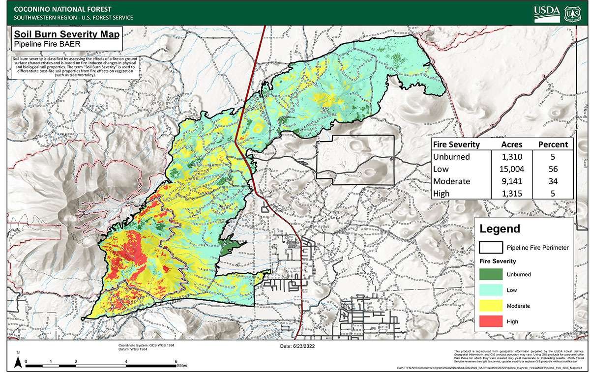
Forest Service Burned Area Emergency Response (BAER) specialists recently completed their field data evaluation to produce the Soil Burn Severity (SBS) map for the Pipeline Fire, which delineate unburned, low, moderate, and high SBS categories.
The BAER team assessing the Pipeline Fire determined that approximately 1,310 acres (1%) of the fire is unburned, approximately 15,004 acres (56%) have low soil burn severity, approximately 9,141 acres (34%) sustained a moderate SBS and approximately 1,315 acres (5%) were identified as having high SBS.
The SBS map product is an estimate of fire effects to soils, not fire effects to vegetation. SBS characterizes fire effects to the soil surface and below ground. Fire effects to vegetation would include an estimate of vegetation mortality and does not always correlate with degree of soil burn severity.
Moderate and high soil burn severity can alter or damage physical, chemical, and biological soil properties resulting in increased runoff, erosion, and negative effects to soil productivity. These soil properties include but are not limited to hydrophobicity (water repellency), soil organic matter content, soil pore space, soil cover (effective litter), and soil structure (degree of aggregation).
Changes to these soil properties determine the degree of soil burn severity. Water repellency often occurs naturally in soils, and it changes as a function of fire. It is frequently discussed as a post-fire effect. Fire can increase the strength and thickness (or depth) of water repellent layers in soil, considerably affecting post-fire water runoff and possibly extending time for recovery of the burned area.
The Pipeline BAER team used remote sensing imagery with field-validated soils data to produce the final SBS map. The BAER team will use the SBS map as an analysis tool to estimate post-fire erosion with subsequent sediment delivery, stream flows and debris flow probabilities. The map is also being shared with cooperating agencies.
The Pipeline Fire soil burn severity map can be downloaded from the Pipeline Fire BAER InciWeb site as a JPEG or PDF version under the Maps tab.
As a reminder, the Coconino National Forest has instituted a Forest Closure Order for the area affected by the Pipeline Fire.

